|
Last Visited: April, 2002
History:
The promontory called Hospital Point, in Beverly on Boston's North Shore, derives its name from a smallpox hospital built there in 1801. The hospital, used as a barracks in the War of 1812, burned down in 1849. It's believed a watch house was previously located there as early as 1711.
The area was the site of an earthwork fort that saw action in the fall of 1775 when the British ship Nautilus fired on the town. Cannons at the point and at Fort Lee in Salem were fired at the Nautilus, which ran aground as the tide fell. The vessel escaped when the tide rose again.
Beverly was an active port for both trade and fishing for many years. But it was the maritime commerce of neighboring Salem that led to the establishment of a lighthouse at Hospital Point.
The Lighthouse Board requested funds "to complete the lighting" of Salem Harbor in 1869, and $30,000 was appropriated by Congress on July 15, 1870, for that purpose.
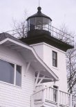
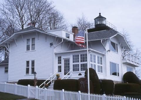
A temporary light was exhibited at Hospital Point beginning on May 1, 1872. By the following year, a 45-foot- square brick lighthouse and adjacent two-story keeper's house were completed. The keeper’s house still stands, with major additions made in 1941, 1968, and 1986, and much of its original trim removed. A brick oil house, built in 1902, also still stands. A garage was added to the station in 1942.
The lighthouse was provided a 3 1/2-order Fresnel lens (right), a rare size in New England. A condensing panel was installed in front of the lens. Because of this panel, the light diminishes in intensity if a mariner veers from the main channel. The panel is considered unique in American lighthouses.
On May 1, 1927, the lighthouse officially became the Hospital Point Range Front Light. A rear range light, created by adapting discarded lightship equipment, was installed in the steeple of Beverly's First Baptist Church, a mile away.
The light, seen through a window in the steeple, is 127 feet above mean high water. The additional light was lined up by incoming mariners with the front range light, as an added guide to Salem Harbor.
The steeple was the only part of the church to survive a disastrous fire in 1975.
Arthur Small, whose wife was killed at New Bedford's Palmer's Island Light in the hurricane of September 1938, became keeper in 1939 after he had recovered from his own injuries. During World War II, Keeper Small maintained a shore patrol in the area and had to check the lights at Derby Wharf and Fort Pickering in addition to Hospital Point. The keeper's house was enlarged during the war to provide barracks for 20 men.
The keeper's dwelling was altered in 1941 to provide barracks for 20 men. The lighthouse was automated in 1947, and since then this tidy lighthouse station has been home to the commander of the First Coast Guard District and his or her family.
Source:
New England Lighthouses: A Virtual Guide
Hours:
The property is a private residence, thus there is no access. It sits at the end of a road with a cul-de-sac and signs saying no parking. Probably best to bicycle or walk to the property.

Latitude/Longitude: 42.546477,-70.855886
Nearest Address: 1 Bayview Ave, Beverly, MA
Directions:
- The lighthouse can be viewed either from a nearby Park (sorry, can't remember the name of it) or you can drive to the cul-de-sac next to the lighthouse. However, there are signs saying no parking on the cul-de-sac.
Here are directions right to the lighthouse:
- Take Route 128 to exit 20 and get onto Route 1A south
- In Beverly take Route 1A 1.7 miles to Route 62 East.
- Turn left onto Route 62 (Elliott St)
- In 1/4 mile after turning left onto Elliott St. Route 62 ends. Turn left onto Hale St.
- Take Hale St. (which becomes Route 127 north) for 1.1 miles and turn right onto E. Corning Rd.
- In 0.3 miles at the intersection with Neptune St. continue straight on Bayview Rd.
- Follow Bayview Rd. 0.25 miles to the end at the cul-de-sac and lighthouse.
View Larger Map
|

