Cleveland Ledge Light
|
Cleveland Ledge Quick Facts
Year Station Established: 1943
Is the Light operational? Yes
Year Light First Lit: 1943
Year Automated: 1978
Shape: Cylindrical on square dwelling
Tower Height: 70 ft.
Original Optic: 4th Order, Fresnel
Present Optic: 190mm
Existing Keepers Quarters? Yes
Year Constructed: 1943
Number of Stories: 2
Architectural Style: Integral
Construction Materials: Concrete
|
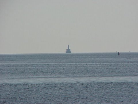
Cleveland Ledge Lighthouse
Near Pocasset, MA
|
Last Visited: November, 2001
History:
The lighthouse was built in 1940-1943. The state of Massachusetts began the project, but turned it over to the Coast Guard in 1941, which, after delays caused by the war, completed it in 1943.
It sits in shallow water on the eastern of the two halves of Cleveland Ledge, which is said to have been named for President Grover Cleveland because he used to fish in the area. It marks the east side of the beginning of the dredged channel leading to the Cape Cod Canal and is the first fixed mark when going northbound through the canal. As it is an important mark in an area subject to fog, it has a racon showing the letter "C".
It was added to the National Register of Historic Places as Cleveland Ledge Light Station in 1987.
As reported by The Standard Times, a New Bedford Massachusetts newspaper on November 26th, The lighthouse has been sold. The paper reported "One group initially filed an application phase but withdrew it in 2009, and the lighthouse was put up for public auction in October 2010. Sandy Boyd of California entered the winning bid of $190,000.
Boyd recently began the permitting process to turn the property into a home, Sclafani said. There does seem to be some issues the new owner would have to fix such as the lighthouse has no water supply, no waste water treatment system and some asbestos issues that may have to be dealt with first.
The Light, flashing 70 feet above the water, was built in 1943 and automated in 1978. The tower sits on 2 stories set up as living quarters over the engine room and supply tanks. The entire structure rests on a 52-foot cylindrical caisson pier.
A 190mm lens flashes white every 10s and a fog signal blasts every 15s.
Source:
Wikipedia
Hours:
The lighthouse is not open to the public and is best viewed by boat.

Latitude/Longitude: 41.630961,-70.694206
Nearest Address: 5 Lighthouse Ln, Pocasset, MA
Directions:
- The above picture was taken near Wings Neck Light in Pocasett. The following directions are to that lighthouse, as are the maps.
- From the rotary on the Cape Cod side of the Bourne Bridge take Route 28 south.
- Stay on Route 28 for 3.4 miles then take a right onto Barlows Landing Rd.
- Follow Barlows Landing Road for 2.1 miles then take a right on Wings Neck Road.
- Stay on Wings Neck Rd. 2.1 miles. You'll then come to a cul-de-sac. The lighthouse is on private property with no trespassing signs. Pull out your long lens and take pictures from a distance.
View Larger Map
|


|