Conimicut Shoal

|
Conimicut Quick Facts
Year Station Established: 1868
Is the Light operational? Yes
Year Light First Lit: 183
Year Automated: 1966
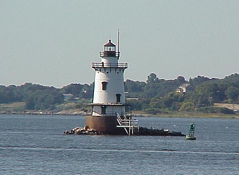
Shape: Conical
Tower Height: 48 ft.
Original Optic: 4th Order, Fresnel
Present Optic: 250mm, Solar
Existing Keepers Quarters? Yes
Year Constructed: 1883
Number of Stories: 3
Architectural Style: Integral
Construction Materials: Cast Iron
|
Conimicut Shoal Lighthouse
Warwick, RI
[Photo 2]
Conimicut Shoal Lighthouse Videos
[Video]
|
Last Visited: September, 2001
History:
The lighthouse established in 1828 at Nayatt Point, on the east side of the entrance to the Providence River, proved insufficient to warn navigators of the dangerous sandbar extending out from Conimicut Point across at the west side.
An unlighted wooden daymark was established as a warning in the middle of the river's mouth by 1858. That first daymark was swept away by ice in 1860, and a spar buoy took its place.
A new granite tower was built in 1866, and at the request of local mariners the daymark was converted into a lighted aid to navigation in November 1868. Nayatt Point Light was then discontinued.
There was no dwelling at the new light, meaning the early keepers had to make a dangerous one-mile rowboat trip to tend the light. In 1874, a five-room house was built on the pier at the light.
In 1882 the old granite tower was torn down and a new cast-iron sparkplug-style light was built, with a fourth-order Fresnel lens and a fixed white light visible for 15 miles. The caisson is sunk 10 feet into the bottom of the bay and is constructed of cast-iron plates. When the caisson was filled with concrete, space was left for a basement with space for water and fuel storage.
The keeper's bedroom was one level below the lantern room. The room was described in 1891 as pretty, with blue walls, an ash bedroom set and arched windows.
The light was fully electrified via cable from shore in 1960, shortly after Fred Mikkelsen left. The IOV lamp had been in use for 47 years. Although many sources say this was the last lighthouse in the nation to be converted to electricity, there was at least one that came later-Burnt Island Light in Maine (1962). The light was automated and the resident keepers were removed in 1963.
The boarded-up lighthouse has held up fairly well in the intervening years. A 1955 boat landing, made of wood, was badly damaged by ice and was replaced by a new steel landing in 1994. Personnel from Coast Guard Aids to Navigation Team Bristol had painted the exterior of the tower in the previous year.
Source:
New England Lighthouses: A Virtual Guide

Latitude/Longitude: 41.716957,-71.345109
Nearest Address: 55D Nayatt Point Ct, Barrington, RI
Directions:
- Use the same directions as those for Nayatt Point. That's where we got a view of Conimicut Lighthouse
- From Providence take Route 195 to exit 6.
- At the end of the ramp take a left onto Route 6.
- At the intersection with Route 103, take a right onto Route 103 (Pawtucket Ave).
- Stay on Route 103 for 4.4 miles and take a right onto Washington Rd.
- Go down Washington Road for 2.4 miles and take a right on Nayatt Rd.
- Take your second left onto Nayatt Point Ct. It's a small road that actually looks like a driveway. Go to the end.
View Larger Map
|


|
![[Photo 2]](https://www.cyberlights.com/lh/ri/images/conimicut/conimicut2.jpg)