Cape Mendocino
|
Cape Mendocino Quick Facts
Year Station Established: 1868
Is the Light operational? No
Year Light First Lit: 1868
Year Deactivated: 1951
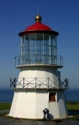
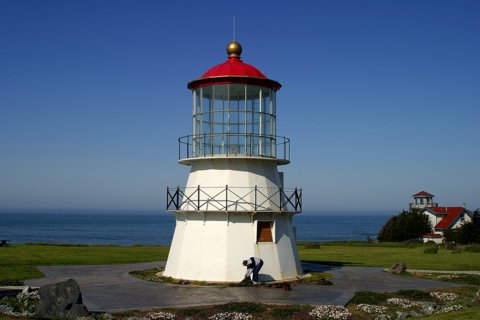
Shape: Pyramidal 16-sided
Tower Height: 43 ft.
Original Optic: 1st Order, Fresnel
Present Optic: REMOVED
Existing Keepers Quarters? No
|
Cape Mendocindo Lighthouse
Shelter, Cove, CA
More Photos
(8 photos, 169KB total download)
|
Last Visited: May, 2003
History:
Cape Mendocino is the western most point in California. It is also one of the most dangerous points of coastline in the state. It became evident by the mid-1800s that a light was needed to guide lumber and steam ships up and down the coast.
September 1867 a tender Shubrick came north to drop off materials and men to build the light. It was shipwrecked thirty miles to the south. A second ship made the journey a couple of months later and successfully dropped off the much needed supplies and men. One year later a barn, a brick house and a carpenter shop stood at the site. Two hundred yards down the hillside and 422 feet above the sea a concrete slab was built to hold the light tower.
Joseph Bein, built the tower in San Francisco. It was constructed of sixteen iron panels that were assembled at the site. The lantern was delivered to Eureka and loaded on to wagons and hauled 40 miles south to the site rather than risk damage by a direct delivery. The first order Fresnel light first shown on December 1, 1868.
The Coast Guard took over in 1939. The light was automated in 1951 and the Fresnel Lens was sent to Ferndale at the Humbolt County Fairgrounds. By 1960, the wooden structures at the site burned to the ground. A modern optic now stands at the site.
In late 1998, a dedicated group of volunteers from Shelter Cove disassembled the lighthouse from its home of 130 years, and transported the components down the coast. The lantern room was taken in one piece by Coast Guard helicopter! Resoration work began, and in June 1999 a new foundation was laid for the lighthouse in Mal Coombs Park in Shelter Cove. The lighthouse is now nearing completion, a genuine success story.
Source:
http://www.westofpch.com/lighthouse/mendocino.html
Source:
http://members.aol.com/fairyfellr/mendo.html
Hours:
The lighthouse is situated in a public park in the middle of town.
Personal Note:
The drive through the mountains sure was interesting! But the early part of the drive was great because you drove through some really nice redwood groves. The woman who was tending to the garden outside of the light was really nice and opened up the lighthouse for us.

Latitude/Longitude: 40.022282,-124.069543
Nearest Address: 1176 Lower Pacific Drive Whitethorn, CA
Directions:
- From Route 101 take the Redwood Drive exit in Garberville. If coming from the south, turn left onto Redwood Drive. If coming from the north, take a right onto Redwood Drive.
- Stay on Redwood Drive Rd for 2.7 miles into Redway, then take a left onto Briceland Thorn Rd.
- Take Briceland Thorn Rd. for appx. 12 miles then bear right onto Shelter Cove Rd. (follow the signs for Shelter Cove).
- After about 9 miles of driving the twisting and turning roads through the mountains, you'll get into Shelter Cove. Take a sharp left onto Machi Rd. At that point you should be able to see the lighthouse in the distance. Drive to the parking lot.
View Larger Map
|


|