Mile Rock
|
Mile Rock Quick Facts
Year Station Established: 1906
Is the Light operational? No
Year Light First Lit: 1906
Year Deactivated: 1966
Shape: Round
Tower Height: 35 ft.
Original Optic: 3rd Order, Fresnel
Present Optic: REMOVED
Existing Keepers Quarters? No
|
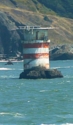
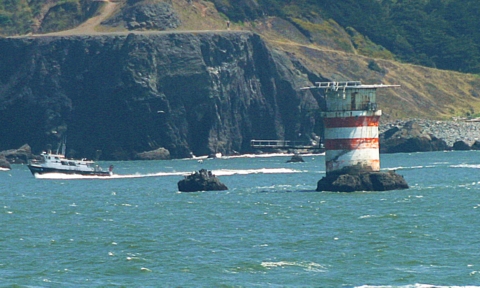
Mile Rock Lighthouse
San Francisco Bay, CA
More Photos
(8 photos, 421KB total download)
Mile Rock Lighthouse Videos
[Video]
|
Last Visited: July, 2012
History:
The worst ship wreck in San Francisco history happened in this area a few years before Mile Rocks Lighthouse was built.
Two hundred people were aboard a liner called the Rio de Janeiro as it entered the San Francisco Golden Gate in a thick fog on February 22, 1901. It struck Fort Point Ledge and began sinking rapidly. Over 100 lives were lost.
Located at the southwestern edge of the Golden Gate in San Francisco, this lighthouse was described as a "steel wedding cake."
Even though this lighthouse was very close to a large city, it was one of the most isolated lighthouses in America. It was too small to allow families so the men had to get used to a lonely life. There was no escaping the blast of the fog signal day or night. Because it was so isolated, the Coast Guard gave the men one week off for every two weeks served.
The fixed third order lens that once shone from Mile Rocks Lighthouse in San Francisco Bay can now be seen hundreds of miles away from its former perch. It now shines landward each night from the lantern room of Old Point Loma Lighthouse in San Diego - its use is only decorative. It was first lit at Mile Rocks in 1906, and was removed upon the station's renovation in 1966. It was installed at Old Point Loma in the 1980's.
Source:
Lighthouse Quest
Personal Note:
It's a real long way from Point Bonita to Mile Rock. The photo above was with a 400mm lens. My digital SLR modifies that by 1.6, so it's a focal length of about 620mm. Not sure if I used my 2x teleconverter to up that to more than 1200mm or not. But it's a long ways away. I almost didn't spot it when we were at Point Bonita. Before I zoomed in it looked more like a trash can painted red and white!
UPDATE 07/2013 - This visit we went to Land's End and took the Land's End trail along the shore, then to the Eagle Point Labyrinth trail, which offered decent views of the light.

Latitude/Longitude: 37.80029,-122.516963
Nearest Address: 1004 Point Lobos Ave, San Francisco, CA
Directions:
- The first photos were taken using a 400mm lens from Point Bonita Light. Go to that page for directions there. The other photos were taken from the Land's End trail.
- An alternative would be to view it from the bluffs at Lincoln Park. But beware, I've read that there are clothing-optional beaches there.
- To get to Lincoln Park from US 101 south of the Golden Gate Bridge, takn US 101 north and take the last exit before the bridge (Lincoln Blvd).
- Turn right onto Lincoln Blvd. Follow that road (it becomes El Camino del Mar) into Lincoln Park.
View Larger Map
|


|