|
Last Visited: May, 2003
History:
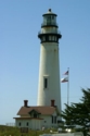
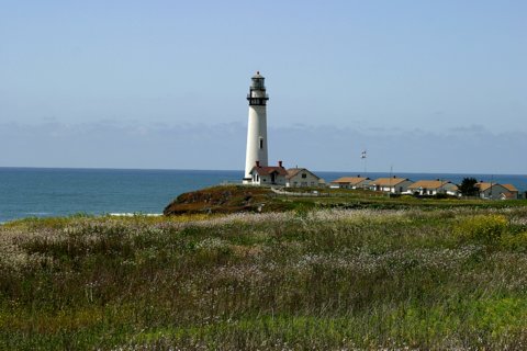
Fifty miles south of San Francisco on winding US Highway One, the 115 foot tall Pigeon Point Light House has been a beacon for those on the sea since Nov. 15, 1872. Resembling the Outer Banks of North Carolina twins, Bodie and Currituck, Pigeon Point is the most photographed lighthouse in California. Located between Santa Cruz and Half Moon Bay, the tower is still an active U.S. Coast Guard aid to navigation, using an automated 24-inch Aero Beacon. The first order Fresnel lens is still in place, but is lighted on special occasions only.
The Pigeon Point light was named for the Yankee Clipper Carrier Pigeon, which sank off the point in 1853. The light was built in 1872 and is the tallest on the Pacific Coast.
A self-guided tour of the grounds is available from 8:00 AM to sunset daily. In addition, a 45 minute, docent-led tour of the tower, including the lens room, is available Saturdays and Sundays, except on rainy days.
Pigeon Point Lighthouse buildings have become a youth hostel operated by the Golden Gate Council of Hostelling International. The four three-bedroom houses next to the lighthouse have overnight lodging for up to 50 people of all ages. Each house has three male or female bunk rooms. Separate bunk rooms can be reserved for families or couples. Hostel guests share bathrooms, kitchens, and living rooms. An outdoor hot tub can be rented in the evenings.
Source:
about.com - California
Source:
Monterey Bay National Maritime Sanctuary
Hours:
Grounds daily/tower open from 11:00 - 4:00 April through September and 10:00 to 3:00 October through March.
Personal Note:
See our Lighthouse Accomodations page for links to the Pigeon Point youth hostel.

Latitude/Longitude: 37.181792,-122.394372
Nearest Address: 210 Pigeon Point Rd, Pescadero, CA
Directions:
- From the Golden Gate Bridge in San Francisco, get on SR1 heading south.
- Stay on SR 1 for about 6.5 miles when SR 1 merges onto I-280 south. Keep going on SR 1 / I-280 south.
- In about 1.5 miles SR 1 exits off of I-280. Take the exit (I believe it's exit 8) and keep on SR 1 south.
- Drive on SR 1 for another 40 miles until you get to Pigeon Point Rd. (you'll see the lighthouse at this point).
- Turn right on Pigeon Point Rd. Follow it to the end and park.
View Larger Map
|

