|
Last Visited: May, 2004
History:
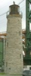
Nestled in between the massive twin-span Skyway Bridge and an aging lift bridge sits a 145-year-old limestone lighthouse, oblivious to the busy traffic passing by. Situated in-harbor on the south bank of the Burlington Canal in Lake Ontario, Canada, the Burlington Bay Main lighthouse is easily overlooked. But once located, it will reward its finder with a treasure that can be easily visited at close range.
In 1832 the Burlington Bay canal was constructed to allow ships unlimited access to Hamilton's harbor from Lake Ontario. Even though two small range lights were installed at the canal's entrance, vessels found it difficult to maneuver within this dark stretch at night. Some ships were even said to have been run aground along the beach by following false lights set up by "wreckers" - scavengers hoping to retrieve lost cargo.
Due to the demands of the distressed mariners and area residents, a 54-foot wooden lighthouse was finally constructed along the Pier. This octagonal-shaped structure was built in 1837 by the American, John L. Williams, and was constructed of clapboard set on a stone foundation.
Strong crosscurrents at the entrance of the canal forced many vessels to scrape their sides along the Piers, sending sparks to ignite the dry wood planking of the pier during the hot summer months. On July 18, 1856, sparks from the steamer Ranger ignited the wooden pier. On that windy day, the fire spread swiftly and engulfed the area, destroying the lighthouse, the ferry house, and the keeper's cottage.
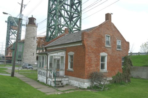
The light keeper spent several months living in a shanty until a new brick keeper's dwelling was built in 1857. After a few delays, the new main lighthouse was completed on October 18, 1858, by John Brown, a prominent lighthouse contractor. The 90-foot cylindrical tower was constructed of limestone, the walls being seven feet thick at the base. This time, government officials had insisted on a fireproof structure for longevity.
Along with the new stone lighthouse, a more modem method of keeping the light was adapted. Instead of using the traditional whale oil to fuel the light, this lighthouse was the first in Canada to switch to the use of coal oil. This immediately caused an uproar among the mariners, fearing it would rob the whalers of their livelihood. The government stayed its ground and ignored the mariners' protests, and by the 1860's most Canadian lighthouses were fueled with coal oil.
Deemed no longer necessary, the Burlington Bay Main Lighthouse was deactivated in 1961 and currently sits abandoned along with the light keeper's red brick house, situated several yards away. Unfortunately, both buildings are showing signs of deterioration. Efforts are currently under way by the Bay Area Restoration Council to develop a historical park highlighting the existing lighthouse and lighthouse keeper's residence, in an effort to preserve this local landmark for years to come.
Source:
Lighthouse Digest
Personal Note:
We happened to be at the lights when the lift bridge, which is right next to the main tower, was raised. The warning horn nearly caused me to jump out of my shoes! It was impressive to see the bridge in action.

Latitude/Longitude: 43.298713,-79.794821
Nearest Address: 1159 Beach Blvd Hamilton, ON L8H 6Z9, Canada
Directions:
- From the QEW (Queen Elizabeth Way) heading east towards Toronto, take exit 93.
- Just before crossing the lift bridge turn left and go under the QEW.
- Continue until you see the entrance to the marina. Turn as though you're going to enter the marina but then turn right into the parking area by the lighthouse.
- The main lighthouse is right at the parking area. The front range light is along the breakwater on the other side of the bridge (walk the breakwater and go under the lift bridge)
View Larger Map
|


