Lynde Point
|
Lynde Point Quick Facts
Year Station Established: 1803
Is the Light operational? Yes
Year Light First Lit: 1839
Year Automated: 1975
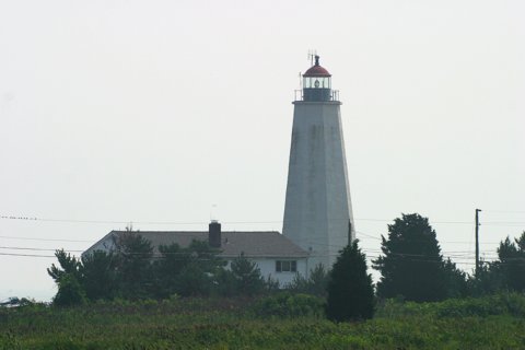
Shape: Octagonal
Tower Height: 65 ft.
Original Optic: 10 Lamps, 9" Reflector
Present Optic: 5th Order, Fresnel
Existing Keepers Quarters? Yes
Year Constructed: 1966
Number of Stories: 2
Architectural Style: Duplex
Construction Materials: Masonry
|
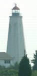
Lynde Point Lighthouse
Old Saybrook, CT
More Photos
(4 photos, 72KB total download)
|
Last Visited: August, 2004
History:
To mark the entrance to the Connecticut River and the harbor of Old Saybrook, the government decided to erect a lighthouse in 1802. The first Lynde Point Light was criticized by mariners for being too dim and too short. A group petitioned for the tower to be raised by 25 feet, but it was decided instead to rebuild the lighthouse. A new 65-foot brownstone tower was erected in 1838.
The lighthouse is similar to the masonry towers built earlier at New London and Faulkner's Island, but Lynde Point is considered to represent the finest work of the three. The original wooden spiral staircase appears to have been replaced during an 1868 renovation. The lighthouse's system of ten lamps and reflectors was replaced in 1852 by a fourth order Fresnel lens. A fifth order lens was installed in 1890. A fog bell was added in 1854.
An 1833 keeper's house remained in use until it was demolished in 1858 and replaced by a new Gothic Revival gambrel-roofed wood-frame house. This house was regrettably destroyed by the Coast Guard in 1966 and replaced by a modern duplex house, against the wishes of the Old Saybrook Historical Society.
ith the addition of the Saybrook Breakwater Light in 1886, Lynde Point became commonly known as the "Inner Light," while the Breakwater Light became known as the "Outer Light."
The light was electrified in 1955 and automated in 1978, but the 1890 Fresnel lens remains in place and Lynde Point Light continues to exhibit a fixed white light as an active aid to navigation. The 1966 duplex house serves as Coast Guard housing.
Source:
New England Lighthouses - A Virtual Guide
Hours:
The lighthouse is at the end of a private road and is difficult to reach on foot. The light itself is not open to the public.

Latitude/Longitude: 41.271453,-72.343239
Nearest Address: 98 Sequassen Ave, Old Saybrook, CT
Directions:
- From New London take I-95 south to exit 68.
- At the end of the ramp continue on Route 1 south to the intersection with Route 154.
- Turn right at the intersection onto Route 1/Route 154.
- Follow that for about 0.5 miles. Route 1 continues straight. Bear left onto Route 154.
- Stay on Route 154 for a little over 2 miles.
- Once you cross over the long bridge, take your first left onto Nibang Ave.
- This will take you right through a golf course community.
- Take your 2nd right onto Fenwick Ave.
- In 0.2 miles take your first left onto Agawam Ave.
- Follow Agawam Ave. to the end then turn left onto Mohegan Ave
- In a couple hundred yards at most, turn right onto Neponset Ave.
- As you drive down Neponset Ave you'll see Lynde Point light, and farther off in the distance to the right of Lynde Point you'll see Saybrook Breakwater.
View Larger Map
|


|