Saybrook Breakwater
|
Saybrook Quick Facts
Year Station Established: 1886
Is the Light operational? Yes
Year Light First Lit: 1886
Year Automated: 1959
Shape: Conical
Tower Height: 48 ft.
Original Optic: 5th Order, Fresnel
Present Optic: 300mm
Existing Keepers Quarters? Yes
Year Constructed: 1886
Number of Stories: 3
Architectural Style: Integral
Construction Materials: Cast Iron
|
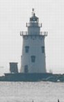
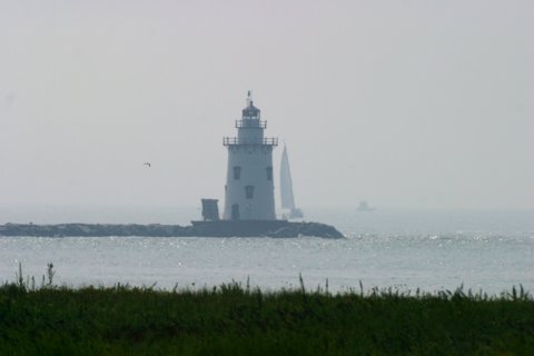
Saybrook Breakwater Lighthouse
Old Saybrook, CT
More Photos
(4 photos, 58KB total download)
|
Last Visited: August, 2004
History:
The harbor of Old Saybrook, at the mouth of the Connecticut River, was limited in its development by the presence of a large sand bar at the harbor entrance. Buoys were placed to mark the bar, but the shifting sand made navigation difficult. In the 1870s two parallel stone jetties were built and a deep channel was dredged between them. In 1882 $20,000 was appropriated by Congress for the construction of a lighthouse on the west jetty. Saybrook Breakwater Light, also known as the Outer Light, was first lighted on June 15, 1886. It is located 1 1/2 miles from Lynde Point Light.
The 49-foot cast-iron tower on a cylindrical foundation is very similar to Connecticut's Stamford Harbor Light. It has a basement, four main floors, a watchroom and a lantern room. It was fitted with a fifth order Fresnel lens exhibiting a fixed white light with a red sector. A new fourth order lens was installed in 1890.
Saybrook Breakwater Light was automated in 1959 and its Fresnel lens was replaced by a modern optic. In the summer of 1996 the Coast Guard painted the lighthouse and removed a 500-gallon fuel tank and a generator at a cost of $64,000.
Saybrook Breakwater Light continues to flash a green light as an active aid to navigation. The lighthouse is visible from several places along the shore. It is at the end of a private road and is difficult to reach on foot.
Source:
New England Lighthouses - A Virtual Guide
Hours:
It is at the end of a private road and is difficult to reach on foot. The light itself is not open to the public.

Latitude/Longitude: 41.263259,-72.342827
Nearest Address: 98 Sequassen Ave, Old Saybrook, CT
Directions:
- From New London take I-95 south to exit 68.
- At the end of the ramp continue on Route 1 south to the intersection with Route 154.
- Turn right at the intersection onto Route 1/Route 154.
- Follow that for about 0.5 miles. Route 1 continues straight. Bear left onto Route 154.
- Stay on Route 154 for a little over 2 miles.
- Once you cross over the long bridge, take your first left onto Nibang Ave.
- This will take you right through a golf course community.
- Take your 2nd right onto Fenwick Ave.
- In 0.2 miles take your first left onto Agawam Ave.
- Follow Agawam Ave. to the end then turn left onto Mohegan Ave.
- In a couple hundred yards at most, turn right onto Neponset Ave.
- As you drive down Neponset Ave you'll see Lynde Point light, and farther off in the distance to the right of Lynde Point you'll see Saybrook Breakwater.
View Larger Map
|


|