|
Last Visited: August, 2004
History:
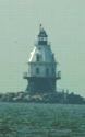
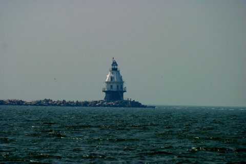
Southwest Ledge is a dangerous rock formation about a mile offshore on the east side of the main channel into New Haven Harbor. In 1845 Fifth Auditor and Superintendent of Lights Stephen Pleasanton had recommended the building of a lighthouse at Southwest Ledge to replace the old New Haven Light at Five Mile Point, but the isolated location made the light prohibitively expensive at that time.
With improvements in lighthouse engineering, the construction of Southwest Ledge Light began in 1873. The lighthouse was one of the first of the nation to be built on a cylindrical iron foundation. This shape allowed floating ice to drift around it in winter rather than becoming trapped around the foundation.
In the summer of 1876 the 45-foot cast-iron, wood-lined lighthouse tower was put in place, and Southwest Ledge Light became operational on January 1, 1877. On the same day the old New Haven Light, or Five Mile Point Light, was extinguished. Not long after the lighthouse was built it became the terminus for a new breakwall in New Haven Harbor.
The Fresnel lens was replaced by a modern lens in 1988. The automated flashing red light and fog signal continue to serve as active aids to navigation.
Source:
New England Lighthouses - A Virtual Guide
Hours:
The lighthouse is not open to the public. It is best seen by boat but you can get a distant view from Five Mile Point Lighthouse at Lighthouse Point Park.

Latitude/Longitude: 41.234381,-72.91219
Nearest Address: 231 Lighthouse Rd, New Haven, CT
Directions:
- From Old Saybrook take Route 95 south to exit 51.
- Exit 51 takes you onto Route 1 south. Follow Route 1 0.9 miles to the intersection with Route 337.
- Turn left onto Route 337 (Townsend Ave).
- Stay on Route 337 for 2.3 miles then turn right onto Lighthouse Rd.
- Take Lighthouse Rd. about 1 mile to the entrance to Lighthouse Point Park. There is an entrance fee in the summer.
- Drive into the park. You'll see the lighthouse over to your right. Park in one of the lots and walk to the lighthouse. In the distance you can also see Southwest Ledge (New Haven Breakwater).
View Larger Map
|
![[Photo 2]](https://www.cyberlights.com/lh/conn/images/southwestledge/southwestledge02.jpg)

