|
Last Visited: July, 2002
History:
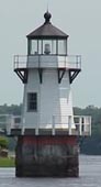
This light is one of four lights located along the Kennebec River on Arrowsic Island that guided ships from the Atlantic Ocean to the shipbuilding town of Bath, Maine. It is the light closest to Bath, near the upper end of Fiddler Reach. It is a white, wooden, octagonal tower built on a square concrete pier. A fifth order Fresnel lens replaced the original lantern lens in 1902. The Fresnel lens was removed around 1975 and has been relocated to the Shore Village Museum in Rockland, Maine. The current lens is a 300 mm modern optic. The tower is currently owned by the Friends of Doubling Point Light, while the grounds and keeper's dwelling are privately owned.
On May 29, 1896, the United States of America purchased a plot of land from Samuel S. Freeman of Arrowsic, Maine. Arrowsic is an island across the Kennebec River from Bath, a city which has often been called "The City of Ships" because of its long history of shipbuilding and its importance in worldwide commerce. Navigation up from the mouth of the Kennebec can be treacherous for large ships.
In 1892 the Annual Report of the Lighthouse Board discussed the need for light and fog signals on the Kennebec River. In 1895 the government took action, and by 1898, four new light stations were established along this lower segment of the Kennebec River: Perkin's Island Light, Squirrel Point Light, the Doubling Point Range Lights, and, of course, Doubling Point Light.
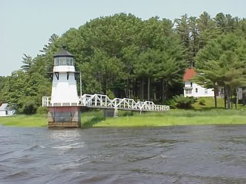
When first built, the Doubling Point Light Station consisted of an octagonal lighthouse, a keeper's dwelling, a small barn, and a fog bell tower. In 1899 the lighthouse was moved from its original foundation to its present location at the end of a long catwalk that extends through the marsh and into the Kennebec River. At the same time, the fog bell was relocated to the lighthouse itself and the fog bell tower was moved to the rear of the property and converted into a garage. The original foundation for the lighthouse tower still lies on a rock ledge at the eastern edge of the station property. In 1901 a boathouse was built, and in 1902, the lighthouse's original lens lantern was replaced by a state-of-the-art, fifth-order fresnel lens. In 1906 a brick oil house was added, and the station was finally complete.
For nearly forty years Doubling Point Light was manned and maintained by the United States Lighthouse Service. During this time, only two keepers served there, Merritt Pinkham (1898-1931) and Charles W. Allen (1931-1935). However, as time passed, the government decided that it would be more efficient to run the Doubling Point Lighthouse from the nearby Range Lights. So on August 13, 1935, the Doubling Point Light Station, with the exception of the lighthouse itself, was sold to a private owner for $2,200. The USLHS continued to maintain the Doubling Point Lighthouse until 1939 when the Coast Guard took over the USLHS. Under Coast Guard management, the lighthouse remained intact for decades. In the mid nineteen-seventies, the fresnel lens was removed from the tower. It is now part of the collection at the Shore Village Museum in Rockland, Maine. In August 1980 the bell was removed by the Coast Guard. Its current whereabouts is unknown. In 1985, the catwalk and the graceful white arches of its railing were replaced with a new walk of unpainted, pressure-treated wood.
Source:
Internet Public Library
Source:
Friends of Doubling Point Light
Hours:
The lighthouse and dwelling are not open to the public but the surrounding grounds are.

Latitude/Longitude: 43.882521,-69.806797
Nearest Address: 198 Doubling Point Rd, Arrowsic, ME
Directions:
- The lighthouse is best seen by boat, but it is possible to get to it by land.
- From Bath, take Route 1 north over the Kennebec River.
- As soon as you get over the bridge, take a right onto the ramp for Route 127.
- At the end of the ramp, take a left onto Route 127.
- Follow Route 127 for 1.9 miles and take a right onto Whitmore's Landing Road.
- Take Whitmore's Landing Rd. for 0.5 miles then turn right onto Old Doubling Road.
- Follow Old Doubling Rd. 0.7 miles to the end.
View Larger Map
|

