|
Last Visited: June, 2004
History:
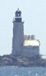
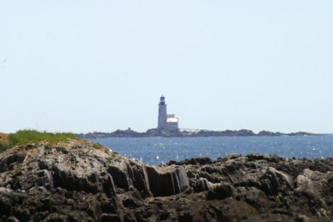
Halfway Rock is a windswept rocky ledge in Casco Bay, about 10 miles east of Portland Head. Its name comes from the fact that it is halfway between Cape Elizabeth and Cape Small in Phippsburg. There are several treacherous ledges in the vicinity that have claimed many vessels.
The possibility of erecting a lighthouse in the vicinity was discussed as early as the 1830s but it wasn't until 1869 that $50,000 was appropriated for the building of a stone tower. Two major storms slowed construction and work was halted for a time because the funds had run out. After an additional $10,000 was appropriated, the 76-foot granite tower was finished in the summer of 1871.
A 43-foot pyramidal skeleton bell tower was bolted to the rock near the lighthouse in 1887, with a 1,000 pound fog bell and striking machinery. A raised walkway connected the bell tower to the lighthouse. Soon after its construction the bell tower survived a fierce December storm that buried Halfway Rock under eight feet of water. In 1888 a new boathouse was built with an upper story containing keeper's quarters. This improved the living conditions, but the tower was always the safest place in a storm.
The fog bell proved inadequate in rough weather, so in 1905 it was replaced by a powerful Daboll trumpet operated by diesel engines.
A new modern house was built for the Coast Guard keepers in 1960, and a new boathouse was also added. In 1975 the keepers were removed for good and the light was automated with a modern DCB 224 optic. The original Fresnel lens went to the museum at the U.S. Coast Guard Academy in New London, Connecticut.
Today the lighthouse tower stands alone on Halfway Rock, still an active aid to navigation. Storms have destroyed the other buildings.
Source:
New England Lighthouses - A Virtual Guide
Personal Note:
It'll need to be a crystal clear day for you to see Halfway Rock from Lands End. We've been to Lands End multiple times and have only been able to see the lighthouse once. To get an idea of how far away the lighthouse is from Lands End, watch our streaming video of the lighthouse as seen from Lands End.
While visiting Bailey Island you may want to stop to check out the crib stone bridge, and right at the bridge eat at the famous Cooks Lobster House - http://www.cookslobster.com/.

Latitude/Longitude: 43.65581,-70.037416
Nearest Address: 2391 Harpswell Islands Road, Bailey Island, ME
Directions:
- Halfway Rock is best seen by boat but a distant view can be seen from Lands End at the tip of Bailey Island.
- From Route 1 in Brunswick, Maine take the exit for Cooks Corner (and Route 24).
- At the intersection, go straight onto Route 24.
- Take Route 24 15.2 miles to its end at Lands End on Bailey Island. During the drive you will drive on Great Island, Orr's Island, then go over a one-of-a-kind crib stone bridge onto Bailey Island.
View Larger Map
|
![[Photo 2]](https://www.cyberlights.com/lh/maine/images/halfway/halfway02.jpg)

