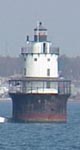
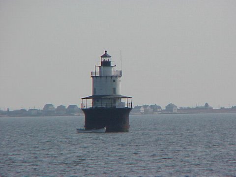
Butler Flats Light
|
Butler Flats Quick Facts
Year Station Established: 1804
Is the Light operational? Yes
Year Light First Lit: 1898
Year Automated: 1978
Shape: Conical on Cylindrical Base
Tower Height: 53 ft.
Original Optic: 5th Order, Fresnel
Present Optic: RB-300 Rotating
Existing Keepers Quarters? Yes
Year Constructed: 1898
Number of Stories:
Architectural Style: Integral
Construction Materials:
|
Butler Flats Lighthouse
New Bedford, MA
More Photos
(4 photos, 100KB total download)
|
Last Visited: November, 2001
History:
Butler Flats Light was first lighted on April 30, 1898, replacing the light atop Fort Taber at Clark's Point. Noted artist, author and engineer, Francis Hopkinson Smith (1838-1915), designed Butler Flats Light. Smith is also credited with building the breakwaters at Block Island, the sea wall at Governor's Island, New York, and the foundation for the Statue of Liberty. The first light keeper was Capt. Amos C. Baker, Jr., a retired New Bedford whaling master who served from 1898 to 1911. His son, Charles A. Baker served as light keeper from 1911 to 1941.
Constructed between 1896 and 1898 at a cost of $34000, Butler Flats is a caisson-style structure 35 feet in diameter. The original lens was French-made with six "bull's eyes" and was of the Fifth Order, or 375 mm in diameter. Accessible only by boat, the station's tower rises 53 feet above mean low tide. It includes basement storage chambers, light keeper's quarters and lantern room. The exterior features three decks: fog deck promenade (complete with canopy, boat davits and launch ladder), lookout deck and lantern room parapet. In 1975, the Coast Guard announced plans to deactivate Butler Flats, move the beacon to the nearby hurricane barrier and dismantle the historic structure. Working with the Coast Guard, New Bedford citizens rallied to save the light. As a result, the light is now owned and operated by the City of New Bedford. Butler Flats was officially added to the National Register of Historic Places on June 15, 1987.
Source:
City of New Bedford

Latitude/Longitude: 41.601869,-70.891478
Nearest Address: 1197 E Rodney French Blvd, New Bedford, MA
Directions:
- Take Interstate 195 into New Bedford.
- Take the exit for Route 18 South, exit 15.
- Stay on Route 18 for 2.5 miles then take a left onto Cove St.
- Take Cove St. for 0.4 miles and turn right onto East Rodney French Blvd.
- Go about 1.3 miles to the intersection with Ricketson St. You can view the lighthouse from along the seawall there.
View Larger Map
|


|