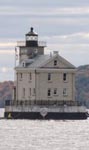
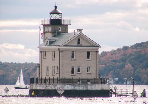
Rondout Light
|
Rondout Quick Facts
Year Station Established: 1838
Is the Light operational? Yes
Year Light First Lit: 1915
Year Automated: 1954
Shape: Square
Tower Height: 48 ft.
Original Optic: 6th Order, Fresnel
Present Optic: 250mm
Existing Keepers Quarters? Yes
Year Constructed: 1915
Number of Stories: 2.5
Architectural Style: 20th Century
Construction Materials: Brick
|
Rondout Lighthouse
Kingston, NY
More Photos
(10 photos, 258KB total download)
Rondout Lighthouse Videos
[Video]
|
Last Visited: October, 2005
History:
The first lighthouse was constructed in 1837 of wood. This structure was quickly damaged by weather and ice. It was replaced in 1867 with a new lighthouse constructed of bluestone on a cut stone base. Both of these lighthouses were located on the Hudson River at the south side of Rondout Creek, much nearer to the shore than the current lighthouse. The circular stone base of the second lighthouse can still be seen.
The newest lighthouse on the Hudson River, started in 1913 and finished and commissioned in 1915, the current Rondout Lighthouse continues an important tradition started in 1837 of marking the vital river port of the Rondout.
Well into the 1940s there was no electricy at the lighthouse. With the installation of electricity the need for a permanent lightkeeper at the lighthouse ended. The last keeper and his family left, the lighthouse was boarded up and the remaining furnishings were removed as automated systems took over operation.
Source:
Hudson Riverlights
Hours:
On weekends and holidays between Memorial Day and Columbus Day guided tours of the lighthouse are available between the hours of 2pm and 5pm. We suggest a donation of $3.00 for adults and $1.00 for children. To visit the interior of the lighthouse at other times you must either be fortunate enough to find the keeper in residence, or you can call ahead and schedule a visit with the keeper Allen Emersonn.
Personal Note:
None of the websites we went to while researching our daytrip of the Hudson River lighthouses talked about a view of the lighthouse from land. We got into Kingston and had a brief glimpse of the lighthouse and decided to drive around to see if there was a better view. We accidentally came across Kingston Point Park and decided to take a short walk to see if there was any view from there. It ended up being a great discovery with a very good view of the lighthouse. Sometimes it pays to just drive around. :-)

Latitude/Longitude: 41.920864,-73.962539
Nearest Address: 141 Delaware Ave, Kingston, NY
Directions:
- From Route 87 take exit 19 in Ulster.
- At the end of the ramp you'll be at a rotary (roundabout for our european friends :-). Go 3/4 around the rotary and take SR 28/Route 587 towards Kingston.
- SR 28 is also Broadway. Take Broadway all the way to the end to the waterfront part of Kingston.
- At the parking lot at the waterfront, take a left onto East Strand St.
- In just over 0.5 miles the road goes to the left and becomes North St. Continue on North St.
- At the blinking light at the intersection with Delaware Ave, turn right onto Delaware Ave.
- In 0.2 miles there is a small parking area at the entrance to the Kingston Point Park. Park there.
- Walk into the park, cross the wooden bridge, and walk along the abandoned train track to a great vantage point of the lighthouse.
View Larger Map
|


|