Valcour Island
|
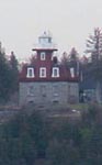
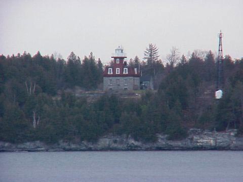
Valcour Island Quick Facts
Year Station Established: 1874
Is the Light operational? NO
Year Light First Lit: 1874
Year Deactivated: 1930
Shape: Octagonal
Tower Height: 35 ft.
Original Optic: 5th Order, Fresnel
Present Optic: REMOVED
Existing Keepers Quarters? Yes
Year Constructed: 1871
Number of Stories: 1.5
Architectural Style: 2nd Empire
Construction Materials: Limestone
|
Valcour Island (Bluff Point) Light
Plattsburgh, New York
| Last Visited: November, 2002 History/Info:
Situated high on a promontory on the western side of Valcour Island is
the Bluff Point Lighthouse. A visit to this beautiful structure,
currently maintained by the Clinton County Historical Association,
should be a highlight of anyone's trip to Lake Champlain.
Placed in service in 1874, the Bluff Point Light was one of the last
lighthouses to be manned on the lake. It guided ships through the
narrow passageway between the island and the New York shore for almost
60 years. Its fifth-order Fresnel lens was seen each evening from 1874
until 1930 when a steel tower was erected just south of the structure.
The base of the lighthouse is constructed of blue limestone, a popular
construction material found in many historic buildings on Lake
Champlain. The attractive design features an octagonal tower atop a
red-shingled mansard roof.
In recent years the U.S. Coast Guard has been negotiating with
lighthouse owners to return the lights to the structures. This
exciting event has actually taken place at several other Lake
Champlain lighthouses, among them Cumberland Head and Windmill Point.
Bluff Point is slated to have its light returned soon also.
Source:
America's Historic Lakes
Hours:
The Lighthouse Committee will be opening the Lighthouse on Valcour
Island for the season of 2003. Starting June 29th it will be open
every Sunday through Aug. 31st. The time of the Open House will be
from 1:00 p.m. until 3:00 p.m. on each of the following dates.*
The dates of the openings are:
May 25
June 29
July 6, 13, 20, 27
August 3, 10, 17, 24, 31
Source:
Clinton County Historical Association
Latitude/Longitude: 44°37.3'N 73°25.8'W
Directions:
click here for
overview map
- From Interstate 87 north take exit 36. At the end of the ramp take a left
onto SR22.
- In 1.54 miles take a left onto S. Junction Rd.
- Follow S. Junction Rd. 2.06 miles to the end. Take a right onto US 9.
- About 0.5 miles or so you'll see a sign on the left for the Peru boat
dock. Turn in there and go to the edge of the lake where you'll see the
lighthouse about 0.7 miles away on Valcour Island.
|
|