|
Last Visited: August, 2002
History:
On September 10, 1813 Commodore Oliver Perry's improvised fleet of nine American vessels defeated and captured a British flotilla of six ships a few miles northwest of Put-in-Bay. The Battle of Lake Erie proved to be the turning point of the War of 1812 in the Old Northwest. Perry's decisive victory neutralized the British naval presence on Lake Erie.
Perry's victory on Lake Erie provided other substantial results for the struggling young nation. It furnished an important boost to sagging American morale during a period when the United States had suffered a string of military defeats. Perry's success forced the British to stand up and take notice of the emerging young nation.
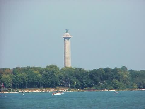
In 1910, as the centennial of Perry's victory approached, the State of Ohio formed a commission to raise funds to construct a monument to commemorate the battle and the peace. The Ohio commission solicited the aid and financial backing of eight additional states, plus that of the federal government. A design competition was sponsored under the auspices of the newly formed US Fine Arts Commission, its first ever competition, and the design by associated architects Joseph H. Freelander and A.D. Seymour was selected.
In October 1912, construction was initiated by the John C. Robinson & Sons Construction Company. When completed in June 1915, at a cost of $480,374.00, Perry's Victory and International Peace Memorial stood 352 feet above Lake Erie. Comprised of 78 courses, or layers of pink Milford, Massachusetts granite, the monument was capped with an 11 ton bronze urn. Interred beneath the rotunda floor of the monument were the remains of three Americans and three British officers killed in the Battle of Lake Erie.
Source:
Put-In-Bay Chamber of Commerce
Hours:
Perry's Victory and International Peace Memorial is open daily from mid May to late October. Winter visits can be arranged by appointment. Upon arrival, 37 steps lead to an elevator which for a small fee takes visitors to an open-air observation platform 317 feet above the lake. The battle site, 10 miles northwest, can be seen on a clear day. A visitor center on the street level provides more information on the monument's history and the island.
Personal Note:
To get to South Bass Island you can take a ferry from Catawba Island to South Bass Island. Miller Ferry offers many ferries each day. Go to http://www.millerferry.com for more details.
Our photos were taken from the boat to South Bass Island. We didn't have the time to go onshore so we settled for these photos. If you have the time, you can go onshore, rent a bicycle or golf cart, and go right up to the memorial. There is an elevator that will take you to the top of the tower where I'm sure there are some spectacular views of the area.

Latitude/Longitude: 41.654189,-82.811043
Nearest Address: 5174 Water St, Port Clinton, OH
Directions:
- To get to Miller Ferry - From OH-2 take exit 124 onto OH-53 north.
- Take OH-53 north for about 6.3 miles to the ferry terminal.
- Once on South Bass Island, at the southern tip, you'll need to get to the northern end of the island. Simply take CR-163 north (Langram Rd) for 2.0 miles then bear left onto Toledo Ave (from the map it looks like they're the same road)
- At the end of Toledo Ave. (in 0.3 miles) take a right onto SR-357, Bayview Ave. In 0.2 miles you'll be at the park where the Perry Memorial is.
View Larger Map
|

![[Photo 2]](https://www.cyberlights.com/lh/ohio/images/perry/perry2.jpg)

