|
Last Visited: May, 2003
History:
Starting in the mid-19th century, Coos Bay had become an important shipping point on the west coast of the United States. The amount of shipping at the time warranted the building of a light at the location, and in 1864, funds were given to build the harbor's light. In 1866, the first light was illuminated. This first tower, which housed a fourth-order Fresnel lens, was nothing more than a 25 feet (7.6 m) octagonal tower with a skeleton base. This tower, located on the west end of an island, was connected to the keeper's residence via a 1,300 feet (400 m) wooden walkway. However, because of its location on the island, the light was greatly exposed to the elements along the Pacific and soon was in need of repairs. Over the next 35 years, much of the station's infrastructure had to be repaired or replaced. Several improvements were also made during this time, including the installation of a fog signal and a new boathouse.
However, sailor's demands for a better light and the threat of erosion meant the end of the first tower, and in 1909, the second tower was lit. Located higher on the island, the new wooden tower stood 100 feet (30 m) tall and provided better illumination. Designed by Carl Leick, the new light was similar in design to Mukilteo Light in the state of Washington. Erosion eventually threatened this light as well, and in 1934, the third light was illuminated.
Containing the second light's fourth-order lens, the third tower was made from concrete to better withstand the inclement weather of the area. This light shared a basic design with Point Robinson Light in Washington. It was also at this time that the first tower, which still stood, was finally destroyed. The second light fared better. The tower was soon removed and the building was converted into an office.
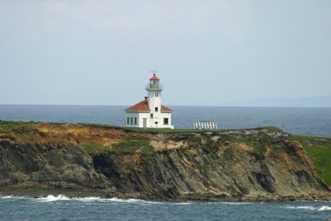
In 1966, the light was automated. Eventually, in 1993, the Fresnel lens was replaced with a modern lens. The light remained a beacon into Coos Bay for the next 12 years, until its decommissioning on January 1, 2006. Today, only the third light remains standing, all other buildings having since been demolished. The site is not open to the public, and the entire area is fenced off. It is visible from the Oregon Coast Trail between Sunset Bay State Park and Shore Acres State Park, and from Bastendorff Beach County Park.
Source:
Wikipedia
Personal Note:
We didn't realize the view we'd get from the state park was so distant. If we did we may not have bothered taking a trip that much off the beaten path (the "beaten path" being US101 in our case). After we viewed the lighthouse we stopped in at a nice little country store right at the bridge that crosses the South Slough. We got to talking with the very pleasant woman behind the counter. She told us that the lighthouse is very rarely open, and when it is it's usually not to the public. She said there's some sort of small bridge that connects the rocks the lighthouse is on to the mainland, and that the bridge is a bit dangerous so the Coast Guard doesn't want anyone out there. Ah well. The people we encountered were very nice and the surrounding area also is very nice. But the view of the lighthouse isn't.

Latitude/Longitude: 43.341308,-124.375418
Nearest Address: Cape Arago Hwy, Coos Bay, OR
Directions:
- From US101 in Coos Bay take Newmark St. heading west.
- Stay on Newmark St. for 3.7 miles then turn left onto Cape Arago Hwy.
- Take Cape Arago Hwy for about 7.7 miles into Sunset Bay State Park. There's a gravel pullout that'll give you a distant view of the lighthouse (probably about 1 mile away).
View Larger Map
|
![[Photo 2]](https://www.cyberlights.com/lh/oregon/images/arago/arago02.jpg)

