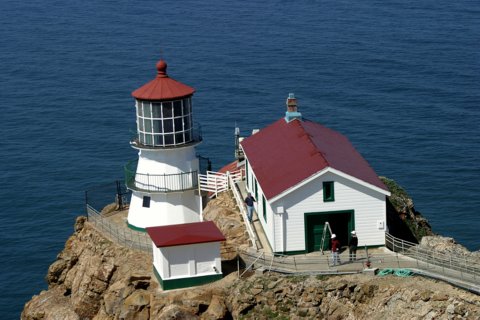
Point Reyes

|
Point Reyes Quick Facts
Year Station Established: 1870
Is the Light operational? No
Year Light First Lit: 1870
Year Deactivated: 1975
Shape: Cylindrical
Tower Height: 35 ft.
Original Optic: 1st Order, Fresnel
Present Optic: 1st Order, Fresnel
Existing Keepers Quarters? Yes
Year Constructed: 1960
Number of Stories: 2
Architectural Style: Modern Triplex
Construction Materials: Wood
|
Point Reyes Lighthouse
Inverness, CA
More Photos
(19 photos, 649KB total download)
|
Last Visited: May, 2003
History:
With over 2.6 million visitors annually, Point Reyes is a unique destination. Far more than a lighthouse situated on a Peninsula, Point Reyes is a distinctive park that was established by President John F. Kennedy in 1962.
Point Reyes is the foggiest area known in California and therefore has an uncommonly low light structure.The light was located at the bottom of the cliff near the water, making it visible for seamen navigating through the fog and along the coast in a rough storm.
The Lighthouse Visitor Center, located on the west side of Point Reyes peninsula, gives visitors information on the structure started in 1855 and erected in 1870 and lifesaving services performed during the 125 years it was utilized as a navigational guide. Visitors beware, there are more than 300 steps in a steep descent to the lighthouse and the only way you can get out is the way you got in, by walking!
Source:
about.com - California
Hours:
Thursday - Monday 10:00am - 4:30pm
Personal Note:
The 308 steps down to the lighthouse were a breeze. The 308 steps back UP wasn't as easy. But they've got 2 or 3 resting areas if you don't want to tackle all those steps at once.
Also, if you're in the area around lunchtime, stop in at Cafe Reyes, which is on SR1 at the south end of the town of Reyes Station. It serves eclectic Mexican style food in a great atmosphere. They have outdoor seating if you want to dine in fresh air and sunshine.

Latitude/Longitude: 37.995486,-123.023193
Nearest Address: 27000 Sir Francis Drake Blvd Inverness, CA
Directions:
- From San Francisco, take US 101 north over the Golden Gate Bridge.
- About 7 miles after going over the bridge, take the exit for SR 1 (Route 1). I believe it's the 5th exit after the bridge.
- Take SR1 north for appx. 28 miles into Point Reyes Station. Take a left onto Sir Francis Drake Blvd.
- Stay on Sir Francis Drake Blvd. for 18.2 miles to the end at the parking lot. Park and walk the (about) 1/2 mile walk up to the top of Point Reyes. From there you have a fun 300+ step descent to the lighthouse (and 300+ ascend back up :-)
View Larger Map
|


|


