Sandy Point
|
Sandy Point Quick Facts
Year Station Established: 1858
Is the Light operational? Yes
Year Light First Lit: 1883
Year Automated: 1963
Shape: Octagonal
Tower Height: 37 ft.
Original Optic: 4th Order, Fresnel
Present Optic: 300mm Solar
Existing Keepers Quarters? Yes
Year Constructed: 1883
Number of Stories: 2.5
Architectural Style: 2nd Empire
Construction Materials: Brick
|
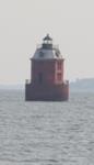
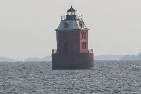
Sandy Point Shoal Lighthouse
Sandy Point State Park
Annapolis, MD
More Photos
(4 photos, 81KB total download)
|
Last Visited: September, 2007
History:
In 1883 the Sandy Point Shoal caisson with a 37-foot Empire-style eight-sided, red brick tower with a white roof and black lantern housing a 4th order Fresnel lens was built. This caisson replaced an earlier Sandy Point Light that had been built on land where Sandy Point State Park is located now. It was an on shore brick tower constructed in 1858 that was situated in a poor location.
Sandy Point Shoal Light has a wooden caisson foundation supporting a round 35-foot-diameter cement-filled cast-iron cylinder on which a 2 1/2-story octagonal brick structure rests. The structure is 24 by 24 feet with truncated corners giving it an octagonal shape. Although not originally painted, the brick portion of the structure is now painted red. The wooden third story mansard roof is painted white, the lantern is painted black, and the gallery deck is painted a dark red/brown. The first two stories were used as living quarters, the third level as the watch room, and the lower level within the cast iron cylinder, as a storage area for water, coal, and oil.
It was electrified in 1929 and fully automated in 1963.
The privy, once located on the southwest side and overhanging the lower gallery deck, was removed sometime since 1989. A pair of davits and a landing ladder once existed on the east side. Another pair of davits and a single loading davit once existed on the west side. The landing ladder on the west side is still used.
The lighthouse is situated in 5 to 7 feet of water approximately 1000 yards east from the beach at Sandy Point State Park and approximately 1 1/2 miles north of the Chesapeake Bay Bridge.
Because of its location, the lighthouse was open to vandalism and in 1979 the Coast Guard discovered that someone had completely smashed the handmade 19th century crystal Fresnel lens, apparently with a baseball bat. It has been replaced with an acrylic lens. Major restoration work was undertaken by the Coast Guard in the late 1980s and early 1990s.
Source:
Chesapeake Chapter, US Lighthouse Society
Hours:
See http://www.dnr.state.md.us/publiclands/southern/sandypoint.html for information on hours and park access fees.

Latitude/Longitude: 39.015899,-76.384574
Nearest Address: S Beach Rd, Annapolis, MD
Directions:
- From Baltimore take SR295 / Baltimore Washington Pkwy to exit 19 south, onto I-695
- In 1.6 miles take exit 4 onto I-97 East (might also be called "South")
- Stay on I-97 for about 10 miles. At this point SR 3 continues straight. Exit left and stay on I-97.
- Continue on I-97 for another 7 miles and merge onto US301 east (towards Annapolis)
- Take US 301 for 9.30 miles and take Exit 32. It's the last exit before the Chesapeake Bay Bridge.
- At the end of the ramp take a left onto Oceanic Rd.
- From here simply follow the signs for Sandy Point State Park. Once you enter the park, follow the road straight towards the water. When you can see the bridge in the distance head to the parking lots off to the left.
View Larger Map
|


|