|
Last Visited: August, 2000
History:
Pumpkin Island is on the south side of the northwestern entrance to Eggemoggin Reach, a narrow channel that separates the mainland from Deer Isle and Little Deer Isle, stretching about 11 miles from Cape Rosier at the northwest to Naskeag Point at the southeast. The reach provides passage from Penobscot Bay to Jericho Bay and Blue Hill Bay.
In the nineteenth century, this area was heavily traveled by vessels carrying lumber and later by summer pleasure craft. The name of the reach was once spelled Algemogin, and it’s said to be derived from a local Indian word meaning “place of the great fish weir.”
An 1852 report of the United States Coast Survey pointed out the importance of Eggemoggin Reach: “This passage, although not so much used as the Muscle Ridge channel, is nearly as useful to commerce, and would be more so were there guides for entering it at night.”
Congress appropriated $3,500 for a light station on Pumpkin Island in August 1852.
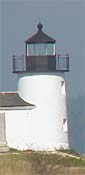
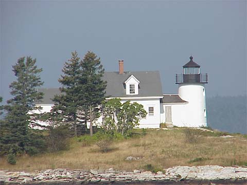
The station consists of a round brick tower, 17 feet tall to the lantern deck, and a one-and-one-half-story colonial Cape dwelling, attached to the tower by a work shed.
The lantern held a fifth-order Fresnel lens, one of the earliest Fresnel lenses used in a Maine lighthouse. In 1889, the lighthouse was fitted with a new lantern, which increased its height by three feet.
In 1934, Pumpkin Island Light was one of several of Maine lighthouses that were discontinued and put up for auction by the government. George Harmon of Bar Harbor bought the station along with two others. Since then the island has passed through several private owners.
An automatic beacon near Pumpkin Island continues today as an aid to navigation. You can get a good view by turning right on Eggemoggin Road just after crossing the bridge from the north to Little Deer Isle and continuing to the end.
Some of the schooners out of Rockland, Rockport, and Camden occasionally pass nearby.
Source:
New England Lighthouses: A Virtual Guide
Personal Note:
Be aware that you are a long distance from this lighthouse and you will need a long lens on your camera to catch an image like you see above. The focal length for the above photo was probably around 500mm.

Latitude/Longitude: 44.309175,-68.742867
Nearest Address: Eggemoggin Rd, Little Deer Isle, ME
Directions:
- From Camden, take Route 1 north for more than 40 miles into East Orland.
- Take a right onto Route 15 and follow for 3.6 miles until you come to Route 199.
- Take a right onto Route 199 and stay on that road for 4.7 miles to it's end.
- Take a left onto Route 175 and follow that road for 8.7 miles until it connects back up with Route 15.
- Stay on Route 15 for 4 miles. You will cross over a bridge onto Little Deer Isle.
- Shortly after crossing onto Little Deer Isle, Route 15 takes a sharp turn to the left. Turn RIGHT onto Eggemoggin Road.
- Take Eggemoggin Road to the end where you can view Pumpkin Island Light off in the distance.
View Larger Map
|